In the past, resilience in the utility industry meant stronger poles, thicker wires, and wider rights-of-way. Today, with extreme weather events increasing in frequency and severity year after year, predictive resilience for utilities means thinking ahead of time, before the storm hits. Customers are beginning to measure utilities on how well they anticipate storm damage, rather than how quickly they respond after the fact.
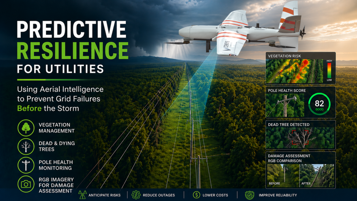
Predictive resilience represents this next phase of evolution. By leveraging aerial intelligence, artificial intelligence, and high-resolution imaging technology, utilities can pinpoint potential weak spots across the grid before severe weather ever hits. By concentrating on four high-impact areas, utilities can stop reacting to crises and start operating proactively. This includes managing vegetation growth, identifying dead or dying trees, and spotting rotten wooden poles before they fail. Additionally, using RGB imaging allows teams to compare before and after photos to accurately assess storm damage where needed.
What makes this approach truly transformative is its scalability. With modern drone networks and advanced data software, utilities can now map entire service territories on a regular cadence. Inspection cycles that once took four to ten years can now be completed every month.
From Response to Prevention
Historically, utilities used helicopters or ground patrols to survey storm damage. Crews would venture out once conditions were safe, documenting destruction and initiating repairs. This reactive process, while essential, offers little opportunity for prevention.
Today, continuous aerial surveillance and advanced analytics are offering a whole new level of intelligence. Fixed-wing drones operating BVLOS can survey tens of thousands of miles of distribution and transmission infrastructure. With every flight, you get an updated picture of grid health and can pinpoint where vegetation, pole health, and environmental stress overlap to create vulnerabilities.
With these aerial insights, utilities can now act beforehand by sending crews out to shore up vulnerable infrastructure, clip high-risk branches, and map out response strategies for individual assets instead of large regions.
Vegetation Encroachment: The First Line of Vulnerability
Vegetation management remains one of the most significant operational expenses for utilities. When high winds push tree branches into conductors or cause overhanging limbs to whip violently, the result is often downed lines, damaged poles, and widespread outages.
The real hurdle has always been the sheer scale of these operations. Patrol crews can spot clearance issues when they’re out in the field, but even the most thorough inspection programs are limited by time and terrain. By the time branches grow back into proximity with lines, inspection cycles can be years behind.
Aerial intelligence completely shifts how these challenges are handled. With high-resolution imagery, teams can map out the entire right-of-way corridors from an aerial perspective and identify the exact locations where branches are impacting energized lines. When wind predictions are overlaid on the imagery, the utility can model how those branches will behave when wind events occur.
Distribution lines often have overlapping canopies, so limbs that might otherwise look benign in normal conditions can whip into power lines when the wind picks up. These branches can swing into conductors and fall, taking poles or hardware with them. Aerial analysis can reveal those specific segments where overhanging vegetation and wind exposure put lines at risk of failure.
The impact of enhanced vegetation management is measurable. According to a peer-reviewed study published in Sustainability (MDPI, 2022), enhanced vegetation management practices reduced trouble spots caused by lower-severity storms by 45.8% to 63.8%, and by 37.3% during severe storms (source). That level of improvement directly translates to fewer outages, lower restoration costs, and stronger reliability scores, representing measurable returns on proactive resilience.
By combining proactive vegetation management with predictive aerial intelligence, utilities can shift from reactive trimming cycles to resilience planning. Instead of waiting for the next storm to reveal vulnerabilities, teams can identify them months in advance and take action before outages occur.
Mitigating the Risk of Dead and Dying Trees
Trees (dead or alive) consistently make up some of the most catastrophic and unpredictable elements of risk when evaluating both transmission and distribution lines. Trees that are alive flex when placed under stress, and trees that are dead snap and break. These risks often exist outside of the maintained right-of-way, where one falling trunk segment can cause multiple spans to be brought down.
With advancements in aerial technology, equipped with multispectral and infrared sensors, trees exhibiting signs of distress can be detected years before they visibly begin to decline. Analysis with AI can detect variations in how leaves reflect light and determine vegetation health stressed by disease or drought, unseen by the human eye.
Assigning these trees a health score and overlaying it with proximity to conductors can help rank risk and act before failure. Combining known risk with historic storm data can also allow utilities to create predictive models that focus on preventative measures. If certain species of trees have a history of failing at 50 mph, AI can detect similar trees in a windy region that should be removed beforehand. Instead of clearing entire corridors, utilities can focus on the most dangerous, threatening reliability and safety.
Rotten Wooden Poles: Structural Failures Waiting to Happen
Vegetation isn’t always the culprit; poles themselves can become failure points. Millions of wooden distribution poles support the electrical infrastructure of North America, many of which were installed decades ago. With age, poles start to rot from exposure to moisture, soil, and insects, causing structural weakness from the inside out.
Core sampling by hand or ground visual inspections have been the traditional way utilities assess pole decay. Both methods work; however, it’s labor-intensive and inconsistent across large systems. Aerial intelligence provides a faster and more uniform solution.
Collapsed or leaning poles mimic dead trees. Excessive force from high winds or saturated soil may cause a stressed pole to break at its base. Predictive analytics allows Utilities to know which poles will fail before Mother Nature makes that decision for them. Replacing stressed poles before they become hazards ensures greater crew safety and fewer customer outages.
RGB Imagery: Documenting Before, During, and After
Predicting risk is only one use-case for high-resolution RGB imagery. Utilities also need reliable before, during, and after imagery to substantiate recovery operations, regulatory reporting, and insurance reimbursements.
Insurance companies and government agencies often require photo or GIS data to process restoration claims. Utilities can prove causality, location, and extent of damage by overlaying pre-existing conditions with disaster impacts. During restoration, crews in the field can also view highly accurate imagery of impacted assets to better coordinate efforts and limit unnecessary field checks. Afterward, the same data supports funding requests, compliance reporting, and long-term asset management.
RGB imagery, aerial intelligence can now be used to create a verifiable record of resilience. Imagery that once felt aspirational is now attainable. Networked drones, BVLOS technology, and AI-driven software have unlocked the scalability of predictive resilience. What once took crews years to inspect can now be mapped in its entirety with autonomous docks, intelligent flight scheduling, and automated data pipelines.
Empowering resilience as an everyday business process. Near real-time vegetation growth, structural movement, and emergent risk can be monitored as it happens. Rural and urban assets can finally be monitored on the same cadence. Predictive resilience has moved from being a future goal to becoming routine.
A Culture of Anticipation
Ultimately, predictive resilience is about the mindset. Utilities that succeed in this transformation treat aerial data and analytics as integral to daily operations. Vegetation management, reliability engineering, and storm response teams share one data environment, aligning action with evidence.
The outcome is a living, learning grid, and one that sees its vulnerabilities before the storm does.
Conclusion
The next generation of resilience will not be defined by how fast utilities rebuild after storms, but by how precisely they predict and prevent failures before they occur. By focusing on vegetation encroachment, dead and dying trees, rotten wooden poles, and RGB imagery for visual documentation, utilities are developing an operational intelligence that sees risk long before it becomes damage.
Enabled by scalable drone and software networks, inspection cycles measured in years are now measured in weeks. Predictive resilience is no longer theoretical. It’s practical, measurable, and ready for system-wide implementation.
When utilities can see their grid every month instead of every decade, they do more than prepare for storms. They get ahead of them.
One response to “Predictive Resilience for Utilities: Using Aerial Intelligence to Prevent Grid Failures”
Hi, I was curious to what software platforms do you use and or recomend for vegetation encroachment and pole/conductor monitoring?