The Sentaero family has added another product member: The TrueView 540 high-performance dual sensor LiDAR and RGB system, now available from Censys Technologies.
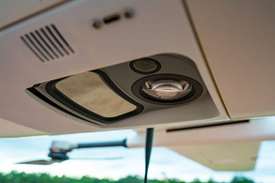
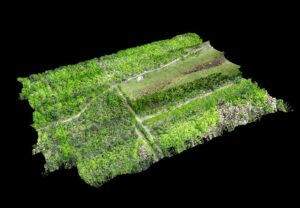
The TrueView 540 is a key addition to the Sentaero platform, enabling operators to collect precise three-dimensional data and high-resolution visual context from a single, tightly integrated payload. The TrueView 540 pairs an engineering grade LiDAR sensor with a high scan rate and a 45 megapixel RGB camera. This powerful combination outperforms the comparable Riegl miniVUX-3, creating a sensor package which allows operators to generate colorized point clouds from a single flight. Additionally, when using the GeoCue processing software (LP360), operators can colorize the point cloud using ray tracing to achieve real 3D colorization. This data product combines the dimensional accuracy of LiDAR with true color imagery, creating a richer, more complete view of the environment. Users need not choose between structural precision or visual context; with the TrueView 540, they get both at once.

For operators, the value of this capability is clear. Equipped with the TrueView 540, a single aircraft can collect high-precision topography and high-resolution color imagery during a single sortie. Operators no longer need to plan and execute separate LiDAR-only and RGB-only flights, minimizing mission time and operational complexity, and reducing total cost of operation. Each flight is more productive, generating more insight in less time.
Equipped with the TrueView 540, the Sentaero 6 enables a wider range of use cases across infrastructure, utilities, transportation, and environmental monitoring. Vegetation and right-of-way monitoring, change detection, corridor mapping, and survey-grade modeling are all use cases that leverage the combined data streams. Operators can now analyze both visual and structural detail together to form a clearer picture of asset health and environmental risk.
The utility of this integrated data doesn’t end with the collection process. Datasets captured with the TrueView 540 can be pushed directly into the Censys software ecosystem, including CensWise. The integrated LiDAR and RGB data work in concert, powering automated and actionable insights. VegCense, for example, provides automated vegetation encroachment detection powered by LiDAR measurements. The integrated RGB imagery allows the user to visually confirm and validate those measurements in the same platform, removing the need for manual cross checking between separate data sets. In this way, a unified and tightly integrated workflow shortens the time from data capture to decision making.
By closing gaps in the data collection and analytics process, teams can work faster and with more confidence. Insights that used to take days can now be delivered in hours, supporting more proactive planning and more responsive operations.
The addition of the TrueView 540 marks the second LiDAR payload offered as part of the Sentaero product line and is a continuation of Censys Technologies’ ongoing efforts to expand enterprise grade aerial intelligence capabilities. This dual sensor solution streamlines and optimizes efficiency for every mission, delivers richer and more accurate intelligence through enhanced analytics, and supports the scalable operations needed to monitor large and complex environments.
Payload flexibility and data quality have never been more important, as organizations look toward autonomous and beyond visual line of sight operations. With the TrueView 540, Censys is expanding the limits of what airborne intelligence can achieve, helping customers see more, know more, and act faster with confidence.
Learn how the TrueView 540 integrates with the Sentaero 6 platform and supports your aerial intelligence missions. Contact the Censys team to discuss your use case.